MHI lets satellite AI detect ships directly in orbit
May 11, 2026
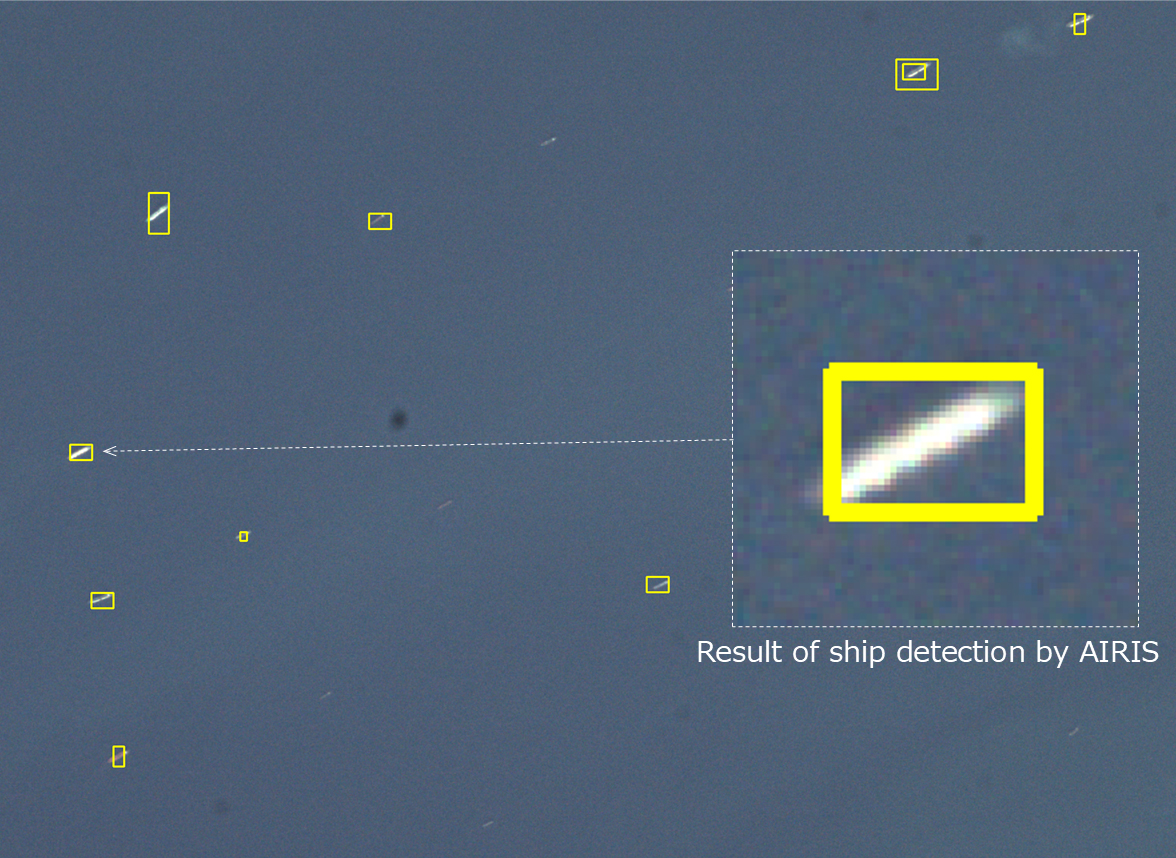
Mitsubishi Heavy Industries reports a successful in-orbit test of AIRIS: the satellite payload detects ships on board instead of waiting for images to be downloaded first.
What this is about
Mitsubishi Heavy Industries said on May 11, 2026 that its satellite-mounted AI object detector AIRIS successfully detected ships in orbit. AIRIS flew on the small RAISE-4 demonstration satellite, launched on December 14, 2025 as part of JAXA’s Innovative Satellite Technology Demonstration-4 mission.
At first, this may sound like a routine space-industry press release. It becomes more interesting because it shows a concrete shift: satellite images do not always have to be fully downloaded to Earth before they become useful. Part of the recognition can happen on board. For maritime monitoring, disaster response and infrastructure observation, that can reduce both latency and data load.
What AIRIS actually does
AIRIS stands for Artificial Intelligence Retraining In Space. The payload combines an AI-capable data processor with an earth observation camera developed by the Tokyo University of Science. On board, the object detector runs on the SOISOC4 space-grade MPU, developed jointly by JAXA and MHI.
In the demonstration, the camera captured maritime images, AIRIS analyzed them directly on the satellite and detected ships. MHI also describes the next step: images gathered during operations are meant to be used on the ground to retrain the AI. The updated model would then be sent back remotely to AIRIS in orbit. This is not just a one-off detector; it is a learning loop between orbit and ground station.
Why it matters
Earth observation creates large amounts of data. If a satellite has to transmit every image in full, usefulness depends on bandwidth, downlink windows and ground stations. Onboard AI can triage first: Where is something relevant? Which images should be transmitted quickly? Which regions need a closer look?
For real people, this matters when speed matters. Illegal fishing, oil spills, blocked sea routes or rescue operations can all benefit from earlier detection. For governments and companies, it also matters that AI hardware in space must work under radiation, temperature swings and tight energy limits. A successful in-orbit test is therefore more than a lab benchmark.
In plain language
Imagine returning from a trip with 2,000 photos and having to copy every single one to your laptop just to find three pictures of your lost suitcase. AIRIS is more like a camera that says while you are still traveling: these five images probably contain the suitcase, send these first.
That does not make the satellite all-knowing. It makes it more selective. A slow image collection can become a faster warning system.
A practical example
A coastal protection team monitors a sea area of 50,000 square kilometers. A conventional satellite captures 1,200 image tiles during a pass and transmits them later in full. Analysis only begins after the downlink. With an onboard detector, the satellite marks 38 tiles with likely ships while still in orbit and prioritizes those for transmission.
If 30 of those are real hits, the team can plan patrols, drones or follow-up satellite passes more precisely. Even if eight markings are false positives, that is better than waiting hours for all raw data. The real question is not only whether the AI can detect ships, but how reliably it performs with clouds, waves, small boats and different viewing angles.
Scope and limits
- MHI does not publish full metrics on precision, false alarms or test scale. The technical claim is a successful demonstration, not a finished global service.
- Ships are a clear and useful use case, but other objects may be much harder, such as small vehicles, damaged infrastructure or partly hidden targets.
- Retraining and updating a model in orbit sounds powerful, but it requires secure update processes. A wrong or manipulated model on a satellite would be a real operational risk.
Still, the step matters: AI is moving closer to the sensors. In space, that means less pure data collection and more decision-making at the edge of the network.
SEO & GEO keywords
Mitsubishi Heavy Industries, AIRIS, satellite AI, onboard AI, ship detection, JAXA, RAISE-4, SOISOC4, earth observation, space-grade MPU, maritime monitoring, edge AI in space
💡 In plain English
AIRIS is a satellite test system that detects ships directly in orbit. That means not every image has to be sent to Earth first. It can make earth observation faster and more selective.
Key Takeaways
- →MHI reports a successful in-orbit test of the AIRIS AI object detector.
- →AIRIS detected ships directly on board a RAISE-4 demonstration satellite.
- →The hardware uses the SOISOC4 space-grade MPU from JAXA and MHI.
- →Future work aims to test a loop of ground retraining and remote model updates in orbit.
- →Metrics on accuracy, false alarms and operating conditions remain open.
FAQ
What is AIRIS?
AIRIS is an MHI payload for AI-based object detection on board a satellite.
What did it detect?
MHI says AIRIS detected ships in maritime satellite imagery.
Why not analyze everything on the ground?
Onboard analysis can prioritize important images and shorten the time to the first useful result.
Is this already a finished service?
No. MHI describes a technology demonstration and does not provide full performance metrics.